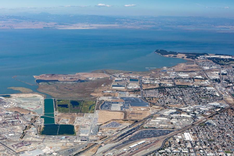
North Richmond Shoreline Living Levee Project

$644,709 in the initial grant, plus a $50,000 augment in 2023
North Richmond Shoreline marshlands (Castro Cove, Wildcat, San Pablo, and North Richmond Marshes), City of Richmond & unincorporated Contra Costa County; Measure AA Region: East Bay
Technical studies and data collection; develop conceptual designs and associated cost estimates; and engage the public, key stakeholders, and the regulatory community.
Vital Fish, Bird and Wildlife Habitat Program; Integrated Flood Protection Program; Shoreline Public Access Program
2023 UPDATE: This project was awarded a $50,000 augmentation to add a tribal engagement storytelling component. In May 2023, the project team revised the Phase 1 living levee alignment to provide improved pedestrian and operations access from the east (along Pittsburgh Ave). In June 2023, the project team completed the 30% Draft deadline and shared it with West County Wastewater for their review and comments. The team also re-engaged with the City of Richmond planning staff on the Collaborative Shoreline Plan.
***
2022 UPDATE: The project team held two stakeholder working group meetings and created several community working groups., They also developed the draft framework for a collaborative shoreline plan, while working on various design approaches for a pilot living levee.
***
The North Richmond Shoreline Living Levee Planning and Preliminary Design Project consists of conducting technical studies and data collection; developing conceptual designs and associated cost estimates; and engaging the public, key stakeholders, and the regulatory community as the initial phase in determining feasibility and alignment options for a living levee. The planning objectives are to create transitional upland habitat, provide flood protection to critical infrastructure and neighboring disadvantaged communities, and improve public access to the North Richmond Shoreline in western Contra Costa County.
West County Wastewater District's (WCWD’s) wastewater treatment plant is at increased risk of flooding due to sea level rise, and WCWD seeks to pursue collaborative, multi-objective, nature-based solutions on and off its property in order to achieve greater habitat benefits and increased flood protection. This project would build on the work of recent shoreline planning efforts focused on preservation and resilience, including:
- The North Richmond Shoreline Community Vision Project was led by the San Francisco Estuary Partnership and completed in 2017. It combined transition zone mapping with strategies for protecting and improving ecosystem services, community health, economic stability, local jobs, education opportunities, safe places for recreation, and vibrant natural habitats. The North Richmond Shoreline Community Vision Project highlighted the WCWD living levee concept as a recommended near-term project.
- The Resilient by Design (RbD) Competition, completed in 2018, dispatched 10 multidisciplinary teams to 10 shoreline areas in the SF Bay to develop innovative sitespecific approaches towards achieving community resiliency to sea level rise. The design firm Mithun was assigned to North Richmond and worked with a local Citizen Advisory Board to dig deeper into the concepts and project opportunities identified in the North Richmond Shoreline Community Vision Project. The Mithun final report identifies the living levee concept and measures to improve shoreline local public access and recreational opportunities as priorities. It further recommends that “The West County Wastewater District’s levee strategy would be coordinated and extended within the greater shoreline to protect the North Richmond neighborhood and existing and planned industrial uses from sea level rise.”
The North Richmond Shoreline, from Castro Cove to Point Pinole Shoreline Regional Park, contains some of the best intact tidal and wetland marshes in the Bay-Delta. It is home to threatened and endangered species such as the California Ridgway’s rail and salt marsh harvest mouse. Sea level rise projections indicate these low elevation habitats will be chronically inundated with 5.5’ of sea level rise combined with a 2-year recurrence interval storm event. This increase in water elevation will submerge existing plant communities, make the soils more saline, and force animal and plant communities to higher ground.
An ecotone slope in the form of a “living” levee, along the upland edge of the shoreline (outboard of the Richmond Parkway), will provide upland transition zone habitat, high tide refugia, and migration space for flora and fauna as sea level rises. The planning effort will also investigate opportunities for offshore habitat restoration activities, such as oyster reefs and eelgrass beds, where appropriate, to attenuate wave action. Depending on the final design alignment and elevations, the planned ecotone slope may also provide flood risk reduction for the critical infrastructure (WCWD’s treatment plant, Republic Service’s solid waste transfer station and sanitary landfill, and Chevron’s oil refinery), transportation systems (Richmond Parkway, railroad) existing along the shoreline, as well as for the adjacent residential communities.
