SAFER Bay Planning Project

Cities of East Palo Alto, Menlo Park, and Palo Alto, San Mateo County; Measure AA Region: West Bay
Planning, Design, and CEQA Documentation
Safe, Clean Water and Pollution Prevention Program; Vital Fish, Bird and Wildlife Habitat Program; Integrated Flood Protection Program; Shoreline Public Access Program.
State Coastal Conservancy
U.S. Fish and Wildlife Service
2023 UPDATE: President Biden spoke about the project on June 19, 2023 at the Baylands Nature Preserve in Palo Alto where he was with California Governor Newsom, promoting the new climate resilience challenge and funding. In February 2023, the Governing Board of the Restoration Authority authorized a grant of up to $3,980,000 to augment the $1,000,000 authorized for the project on June 24, 2022 the San Francisquito Creek Joint Powers Authority (SFCJPA) to conduct planning, perform data collection and analysis, develop design plans, and prepare program-level and project-level California Environmental Quality Act (CEQA) documentation for the Strategy to Advance Flood Protection, Ecosystems and Recreation along San Francisco Bay (SAFER Bay) Project in San Mateo County. The initial grant was an amount substantially less than that requested by the SFCJPA . Staff recommended a smaller amount because Authority funding was limited and the project was identified as being a strong candidate for other sources of funding based on its proposed flood protection benefits. The SFCJPA reapplied to the Authority for additional funding in grant round 6 and was recommended for almost full funding because of significant project benefits, the availability of more funding, and in consideration of the need to balance funding for projects between the four regions of the Bay.
***
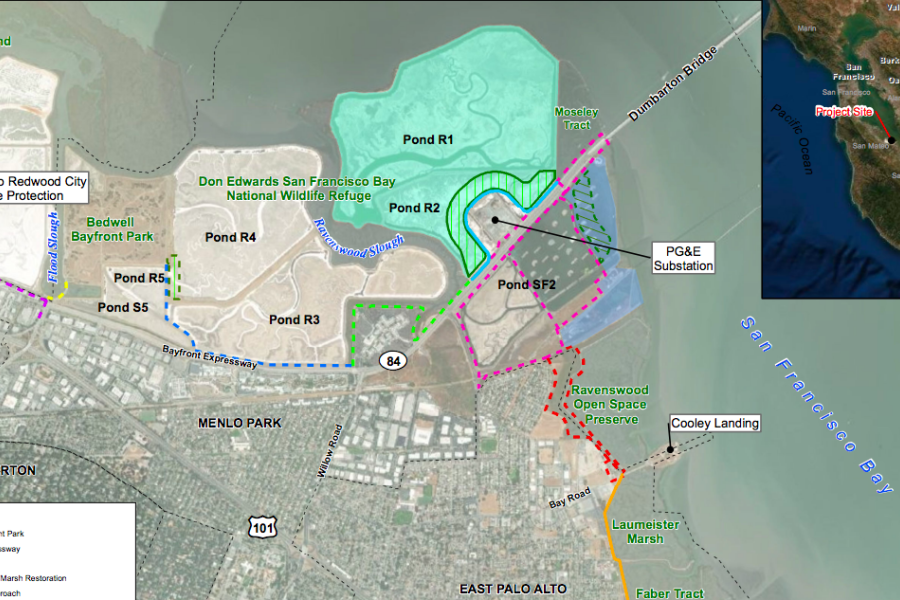
The SAFER Bay Planning Project will lead to coastal flood protection for communities in East Palo Alto and Menlo Park as well as restored tidal wetland habitat and improved recreational opportunities along seven miles of the San Francisco Bay shoreline in San Mateo County. Currently, areas within East Palo Alto and Menlo Park are exposed to coastal flooding from San Francisco Bay which is predicted to worsen with sea level rise. The project will design flood protection elements to current Federal Emergency Management Agency (FEMA) coastal flood protection standards plus an additional 3.5 feet of tidal elevation to account for anticipated sea level rise.
The project will integrate traditional flood protection with the restoration and enhancement of more than 550 acres of wetlands to create a more resilient and biologically diverse shoreline environment.
